


Lacs des Bouillouses

donda
User GUIDE
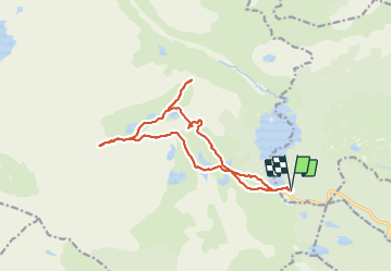

Length
16.4 km

Max alt
2492 m

Uphill gradient
642 m
Km-Effort
25 km

Min alt
2004 m

Downhill gradient
641 m
Boucle
Yes
Creation date :
2021-07-17 06:18:19.905
Updated on :
2021-07-20 13:03:35.045
5h34
Difficulty : Medium

FREE GPS app for hiking
 SityTrail
IGN / Geographical institutes
SityTrail Plus
The world is yours!
About
Trail Walking of 16.4 km to be discovered at Occitania, Pyrénées-Orientales, Les Angles. This trail is proposed by donda.
Photos


Positioning
Country:
France
Region :
Occitania
Department/Province :
Pyrénées-Orientales
Municipality :
Les Angles
Location:
Unknown
Start:(Dec)
Start:(UTM)
418252 ; 4712400 (31T) N.
Comments