


Fréland - Sapin du français

duchaine.nicolas
User
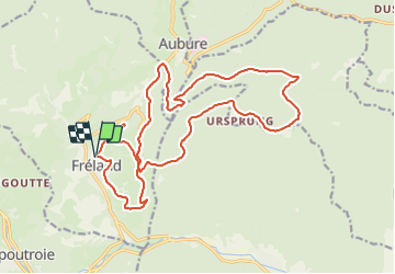

Length
20 km

Max alt
883 m

Uphill gradient
588 m
Km-Effort
28 km

Min alt
448 m

Downhill gradient
586 m
Boucle
Yes
Creation date :
2021-07-25 07:33:39.259
Updated on :
2021-08-17 11:43:16.877
1h27
Difficulty : Very easy
1h27
Difficulty : Very easy

FREE GPS app for hiking
 SityTrail
IGN / Geographical institutes
SityTrail Plus
The world is yours!
About
Trail Mountain bike of 20 km to be discovered at Grand Est, Haut-Rhin, Fréland. This trail is proposed by duchaine.nicolas.
Positioning
Country:
France
Region :
Grand Est
Department/Province :
Haut-Rhin
Municipality :
Fréland
Location:
Unknown
Start:(Dec)
Start:(UTM)
365794 ; 5337177 (32U) N.
Comments