


position voiture 1 cenis

lionel4806
User

Length
1.4 km

Max alt
1904 m

Uphill gradient
30 m
Km-Effort
1.8 km

Min alt
1875 m

Downhill gradient
7 m
Boucle
No
Creation date :
2021-07-27 19:13:07.175
Updated on :
2021-07-28 06:46:56.054
16m
Difficulty : Very easy

FREE GPS app for hiking
 SityTrail
IGN / Geographical institutes
SityTrail Plus
The world is yours!
About
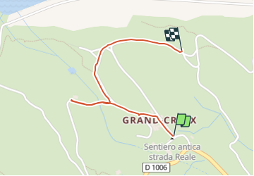
Trail Car of 1.4 km to be discovered at Auvergne-Rhône-Alpes, Savoy, Val-Cenis. This trail is proposed by lionel4806.
Description
position
Positioning
Country:
France
Region :
Auvergne-Rhône-Alpes
Department/Province :
Savoy
Municipality :
Val-Cenis
Location:
Lanslebourg-Mont-Cenis
Start:(Dec)
Start:(UTM)
339536 ; 5009343 (32T) N.
Comments