


MfeXX7dSMOw

norbertmarteau
User
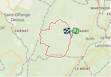

Length
11.6 km

Max alt
1433 m

Uphill gradient
682 m
Km-Effort
21 km

Min alt
888 m

Downhill gradient
686 m
Boucle
Yes
Creation date :
2021-07-29 19:00:18.867
Updated on :
2021-07-29 19:01:16.725
4h42
Difficulty : Very difficult

FREE GPS app for hiking
 SityTrail
IGN / Geographical institutes
SityTrail Plus
The world is yours!
About
Trail Walking of 11.6 km to be discovered at Auvergne-Rhône-Alpes, Savoy, Arith. This trail is proposed by norbertmarteau.
Points of interest


Positioning
Country:
France
Region :
Auvergne-Rhône-Alpes
Department/Province :
Savoy
Municipality :
Arith
Location:
Unknown
Start:(Dec)
Start:(UTM)
271649 ; 5066477 (32T) N.
Comments