


2021-07-30_21h15m22_Les Cortalets - 27-07-2021

rgo76
User
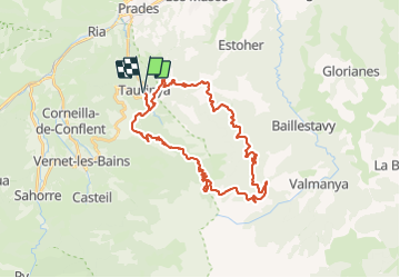

Length
39 km

Max alt
2158 m

Uphill gradient
1856 m
Km-Effort
63 km

Min alt
541 m

Downhill gradient
1859 m
Boucle
Yes
Creation date :
2021-07-30 19:15:23.563
Updated on :
2021-07-30 19:15:28.642

FREE GPS app for hiking
 SityTrail
IGN / Geographical institutes
SityTrail Plus
The world is yours!
About
Trail of 39 km to be discovered at Occitania, Pyrénées-Orientales, Taurinya. This trail is proposed by rgo76.
Positioning
Country:
France
Region :
Occitania
Department/Province :
Pyrénées-Orientales
Municipality :
Taurinya
Location:
Unknown
Start:(Dec)
Start:(UTM)
452958 ; 4714259 (31T) N.
Comments