


2021-08-02_18h03m18_Quelques_pas_sur_le_GR57-8215960-1627918807-848
© OpenStreetMap contributors


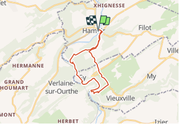
Length
10.9 km
Max alt
234 m
Uphill gradient
311 m
Km-Effort
15.1 km
Min alt
114 m
Downhill gradient
311 m
Boucle
Yes
Creation date :
2021-08-02 16:03:18.791
Updated on :
2021-08-02 16:03:20.137
FREE GPS app for hiking
 SityTrail
IGN / Geographical institutes
SityTrail Plus
The world is yours!
About
Trail of 10.9 km to be discovered at Wallonia, Liège, Hamoir. This trail is proposed by frederic.lorimier@skynet.be.
Positioning
Country:
Belgium
Region :
Wallonia
Department/Province :
Liège
Municipality :
Hamoir
Location:
Unknown
Start:(Dec)
Start:(UTM)
680118 ; 5588949 (31U) N.
Comments
Super rando avec rochers à escalader, grotte à explorer et paysages magnifiques à admirer. Que du bonheur !