


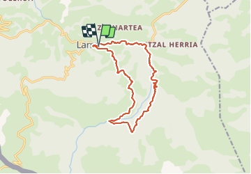
Larrau camping pont suspendu Holzarte

taguette
User

Length
15.1 km

Max alt
856 m

Uphill gradient
715 m
Km-Effort
25 km

Min alt
395 m

Downhill gradient
712 m
Boucle
Yes
Creation date :
2021-08-06 04:57:23.197
Updated on :
2021-08-06 08:21:46.7
3h22
Difficulty : Very difficult

FREE GPS app for hiking
 SityTrail
IGN / Geographical institutes
SityTrail Plus
The world is yours!
About
Trail Walking of 15.1 km to be discovered at New Aquitaine, Pyrénées-Atlantiques, Larrau. This trail is proposed by taguette.
Positioning
Country:
France
Region :
New Aquitaine
Department/Province :
Pyrénées-Atlantiques
Municipality :
Larrau
Location:
Unknown
Start:(Dec)
Start:(UTM)
666917 ; 4764796 (30T) N.
Comments