


5519946-Pic de l'Aspre Caraybat

pidjam
User
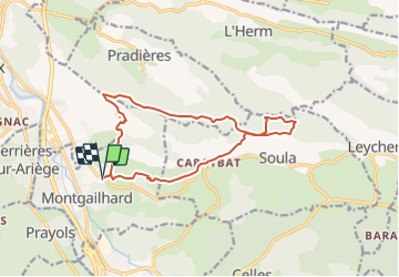

Length
14.8 km

Max alt
1004 m

Uphill gradient
719 m
Km-Effort
24 km

Min alt
459 m

Downhill gradient
717 m
Boucle
Yes
Creation date :
2021-08-09 16:33:54.119
Updated on :
2021-08-11 11:49:52.8
5h30
Difficulty : Very difficult

FREE GPS app for hiking
 SityTrail
IGN / Geographical institutes
SityTrail Plus
The world is yours!
About
Trail Walking of 14.8 km to be discovered at Occitania, Ariège, Montgaillard. This trail is proposed by pidjam.
Description
projet de rando
Positioning
Country:
France
Region :
Occitania
Department/Province :
Ariège
Municipality :
Montgaillard
Location:
Unknown
Start:(Dec)
Start:(UTM)
389082 ; 4754861 (31T) N.
Comments