


lanoux

JimBlues
User
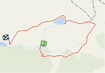

Length
5.1 km

Max alt
1924 m

Uphill gradient
227 m
Km-Effort
8.2 km

Min alt
1705 m

Downhill gradient
252 m
Boucle
No
Creation date :
2021-08-07 09:14:14.078
Updated on :
2021-08-10 06:36:43.516
2h26
Difficulty : Medium

FREE GPS app for hiking
 SityTrail
IGN / Geographical institutes
SityTrail Plus
The world is yours!
About
Trail Walking of 5.1 km to be discovered at Occitania, Pyrénées-Orientales, Porté-Puymorens. This trail is proposed by JimBlues.
Positioning
Country:
France
Region :
Occitania
Department/Province :
Pyrénées-Orientales
Municipality :
Porté-Puymorens
Location:
Unknown
Start:(Dec)
Start:(UTM)
408070 ; 4711606 (31T) N.
Comments