


rateau d'aussois

lionel4806
User
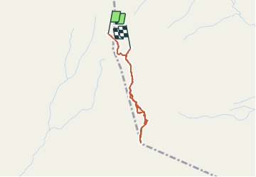

Length
2.6 km

Max alt
3117 m

Uphill gradient
228 m
Km-Effort
5.7 km

Min alt
2896 m

Downhill gradient
240 m
Boucle
No
Creation date :
2021-08-10 09:45:31.947
Updated on :
2021-08-10 14:35:26.399
3h03
Difficulty : Easy

FREE GPS app for hiking
 SityTrail
IGN / Geographical institutes
SityTrail Plus
The world is yours!
About
Trail Walking of 2.6 km to be discovered at Auvergne-Rhône-Alpes, Savoy, Villarodin-Bourget. This trail is proposed by lionel4806.
Description
rando
Positioning
Country:
France
Region :
Auvergne-Rhône-Alpes
Department/Province :
Savoy
Municipality :
Villarodin-Bourget
Location:
Unknown
Start:(Dec)
Start:(UTM)
318741 ; 5013956 (32T) N.
Comments