


Tour d'Alsace Rouffac

famiski
User
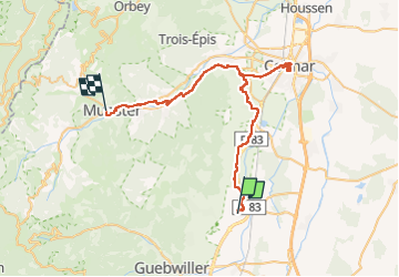

Length
47 km

Max alt
409 m

Uphill gradient
471 m
Km-Effort
52 km

Min alt
188 m

Downhill gradient
289 m
Boucle
No
Creation date :
2021-08-11 08:00:36.646
Updated on :
2022-05-01 11:56:14.615
3h48
Difficulty : Very difficult

FREE GPS app for hiking
 SityTrail
IGN / Geographical institutes
SityTrail Plus
The world is yours!
About
Trail Bicycle tourism of 47 km to be discovered at Grand Est, Haut-Rhin, Rouffach. This trail is proposed by famiski.
Description
Tour d Alsace
Positioning
Country:
France
Region :
Grand Est
Department/Province :
Haut-Rhin
Municipality :
Rouffach
Location:
Unknown
Start:(Dec)
Start:(UTM)
372691 ; 5312642 (32T) N.
Comments