


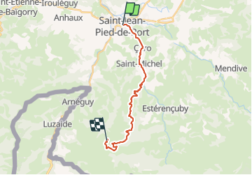
Compostelle - Camino Frances - J1 : de St Jean Pied de Port à la Vierge d'Orisson

webmammuth
User

Length
19 km

Max alt
1104 m

Uphill gradient
1108 m
Km-Effort
31 km

Min alt
173 m

Downhill gradient
187 m
Boucle
No
Creation date :
2021-08-11 11:21:25.965
Updated on :
2021-08-11 18:39:27.652
7h01
Difficulty : Difficult

FREE GPS app for hiking
 SityTrail
IGN / Geographical institutes
SityTrail Plus
The world is yours!
About
Trail Walking of 19 km to be discovered at New Aquitaine, Pyrénées-Atlantiques, Saint-Jean-Pied-de-Port. This trail is proposed by webmammuth.
Description
Compostelle - Camino Frances - J1 : de St Jean Pied de Port à la Vierge d'Orisson
Photos

Positioning
Country:
France
Region :
New Aquitaine
Department/Province :
Pyrénées-Atlantiques
Municipality :
Saint-Jean-Pied-de-Port
Location:
Unknown
Start:(Dec)
Start:(UTM)
643314 ; 4780520 (30T) N.
Comments