


Aubure - Chalet Weibel (12/08/2021)

Richard68500
User
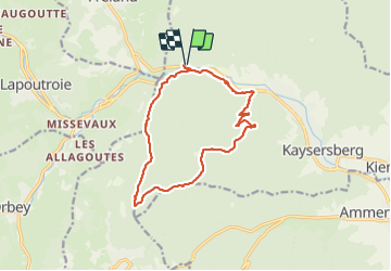

Length
13.8 km

Max alt
750 m

Uphill gradient
579 m
Km-Effort
22 km

Min alt
314 m

Downhill gradient
590 m
Boucle
Yes
Creation date :
2021-08-12 07:44:29.862
Updated on :
2021-08-12 16:27:13.262
4h25
Difficulty : Medium

FREE GPS app for hiking
 SityTrail
IGN / Geographical institutes
SityTrail Plus
The world is yours!
About
Trail Walking of 13.8 km to be discovered at Grand Est, Haut-Rhin, Kaysersberg-Vignoble. This trail is proposed by Richard68500.
Description
Agréable randonnée avec piquenique au Chalet Jean Weibel.
Photos
 - Photo 1")
 - Photo 2")
Positioning
Country:
France
Region :
Grand Est
Department/Province :
Haut-Rhin
Municipality :
Kaysersberg-Vignoble
Location:
Kaysersberg
Start:(Dec)
Start:(UTM)
367509 ; 5335328 (32U) N.
Comments
Attention : randonnée impossible à effectuer en ce moment (mars 2023, et sans doute pour un bon bout de temps) car le tronçon rectangle rouge et blanc à partir de la chapelle St Michel, longeant la route D 415, est absolument impraticable.