


Etang de la Glaçière

benat40
User
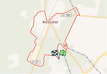

Length
12.4 km

Max alt
49 m

Uphill gradient
118 m
Km-Effort
14 km

Min alt
23 m

Downhill gradient
118 m
Boucle
Yes
Creation date :
2021-08-13 06:19:58.466
Updated on :
2021-08-13 08:56:17.3
2h34
Difficulty : Very easy

FREE GPS app for hiking
 SityTrail
IGN / Geographical institutes
SityTrail Plus
The world is yours!
About
Trail Walking of 12.4 km to be discovered at New Aquitaine, Landes, Saint-Vincent-de-Paul. This trail is proposed by benat40.
Positioning
Country:
France
Region :
New Aquitaine
Department/Province :
Landes
Municipality :
Saint-Vincent-de-Paul
Location:
Unknown
Start:(Dec)
Start:(UTM)
661937 ; 4847785 (30T) N.
Comments