


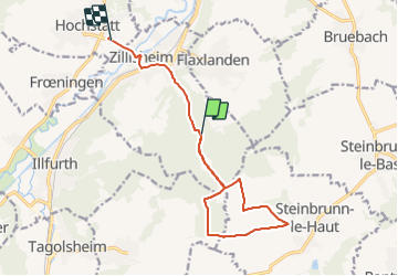
Autour du grand canon

jmbilger
User

Length
12.6 km

Max alt
409 m

Uphill gradient
217 m
Km-Effort
15.7 km

Min alt
245 m

Downhill gradient
265 m
Boucle
No
Creation date :
2021-08-26 12:54:24.0
Updated on :
2021-08-26 15:33:45.871
2h19
Difficulty : Difficult

FREE GPS app for hiking
 SityTrail
IGN / Geographical institutes
SityTrail Plus
The world is yours!
About
Trail Walking of 12.6 km to be discovered at Grand Est, Haut-Rhin, Zillisheim. This trail is proposed by jmbilger.
Positioning
Country:
France
Region :
Grand Est
Department/Province :
Haut-Rhin
Municipality :
Zillisheim
Location:
Unknown
Start:(Dec)
Start:(UTM)
373366 ; 5282121 (32T) N.
Comments