


formigueres station ski - camporeils 10km 890m

Erius
User
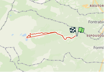

Length
12.5 km

Max alt
2418 m

Uphill gradient
881 m
Km-Effort
24 km

Min alt
1757 m

Downhill gradient
879 m
Boucle
Yes
Creation date :
2021-08-28 07:19:41.693
Updated on :
2021-08-28 17:19:20.553
3h00
Difficulty : Medium

FREE GPS app for hiking
 SityTrail
IGN / Geographical institutes
SityTrail Plus
The world is yours!
About
Trail Walking of 12.5 km to be discovered at Occitania, Pyrénées-Orientales, Formiguères. This trail is proposed by Erius.
Description
1 bout de piste au départ de la station par oratoire et Jacques. forêt. bout de piste forêt et crêtes enduites. Belle vue sur les camporeils . descente 170m
et retour idem
Positioning
Country:
France
Region :
Occitania
Department/Province :
Pyrénées-Orientales
Municipality :
Formiguères
Location:
Unknown
Start:(Dec)
Start:(UTM)
423755 ; 4719463 (31T) N.
Comments