


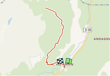
73 - BONNEVAL SUR ARC

AndreLACOMBE
User

Length
9.6 km

Max alt
2290 m

Uphill gradient
621 m
Km-Effort
17.9 km

Min alt
1733 m

Downhill gradient
621 m
Boucle
Yes
Creation date :
2021-08-30 08:14:53.745
Updated on :
2021-08-30 14:51:34.642
6h34
Difficulty : Medium

FREE GPS app for hiking
 SityTrail
IGN / Geographical institutes
SityTrail Plus
The world is yours!
About
Trail Walking of 9.6 km to be discovered at Auvergne-Rhône-Alpes, Savoy, Bessans. This trail is proposed by AndreLACOMBE.
Description
Parking hameau du Villaron vers le pont et montée au Vallon. Belle randonnée sans difficultés majeures. Retour par le même itinéraire.
Positioning
Country:
France
Region :
Auvergne-Rhône-Alpes
Department/Province :
Savoy
Municipality :
Bessans
Location:
Unknown
Start:(Dec)
Start:(UTM)
344517 ; 5021724 (32T) N.
Comments