


fort de la Tura

geoffrayLayeux
User
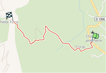

Length
1.5 km

Max alt
2447 m

Uphill gradient
349 m
Km-Effort
5 km

Min alt
2086 m

Downhill gradient
0 m
Boucle
No
Creation date :
2021-08-30 17:01:24.2
Updated on :
2021-08-30 17:01:26.224
1h08
Difficulty : Easy

FREE GPS app for hiking
 SityTrail
IGN / Geographical institutes
SityTrail Plus
The world is yours!
About
Trail Walking of 1.5 km to be discovered at Auvergne-Rhône-Alpes, Savoy, Val-Cenis. This trail is proposed by geoffrayLayeux.
Positioning
Country:
France
Region :
Auvergne-Rhône-Alpes
Department/Province :
Savoy
Municipality :
Val-Cenis
Location:
Unknown
Start:(Dec)
Start:(UTM)
335265 ; 5013995 (32T) N.
Comments