


refuge de l'arpont

geoffrayLayeux
User
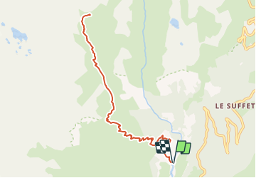

Length
10.7 km

Max alt
2300 m

Uphill gradient
959 m
Km-Effort
24 km

Min alt
1347 m

Downhill gradient
958 m
Boucle
Yes
Creation date :
2021-08-31 16:15:23.826
Updated on :
2021-08-31 16:15:26.239
5h20
Difficulty : Very difficult

FREE GPS app for hiking
 SityTrail
IGN / Geographical institutes
SityTrail Plus
The world is yours!
About
Trail Walking of 10.7 km to be discovered at Auvergne-Rhône-Alpes, Savoy, Val-Cenis. This trail is proposed by geoffrayLayeux.
Positioning
Country:
France
Region :
Auvergne-Rhône-Alpes
Department/Province :
Savoy
Municipality :
Val-Cenis
Location:
Termignon
Start:(Dec)
Start:(UTM)
328563 ; 5017949 (32T) N.
Comments