


freudstein ruine

jcschubnel
User
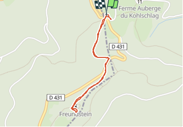

Length
1.8 km

Max alt
910 m

Uphill gradient
83 m
Km-Effort
2.9 km

Min alt
820 m

Downhill gradient
84 m
Boucle
Yes
Creation date :
2021-09-02 11:39:59.151
Updated on :
2021-09-02 16:47:57.599
1h03
Difficulty : Easy

FREE GPS app for hiking
 SityTrail
IGN / Geographical institutes
SityTrail Plus
The world is yours!
About
Trail Walking of 1.8 km to be discovered at Grand Est, Haut-Rhin, Soultz-Haut-Rhin. This trail is proposed by jcschubnel.
Positioning
Country:
France
Region :
Grand Est
Department/Province :
Haut-Rhin
Municipality :
Soultz-Haut-Rhin
Location:
Unknown
Start:(Dec)
Start:(UTM)
359983 ; 5304170 (32T) N.
Comments