


la rhune

bouscaillou
User
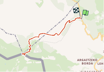

Length
10.5 km

Max alt
899 m

Uphill gradient
769 m
Km-Effort
21 km

Min alt
171 m

Downhill gradient
766 m
Boucle
Yes
Creation date :
2021-09-04 08:26:03.549
Updated on :
2021-09-04 15:25:50.204
6h41
Difficulty : Very difficult

FREE GPS app for hiking
 SityTrail
IGN / Geographical institutes
SityTrail Plus
The world is yours!
About
Trail Walking of 10.5 km to be discovered at New Aquitaine, Pyrénées-Atlantiques, Sare. This trail is proposed by bouscaillou.
Positioning
Country:
France
Region :
New Aquitaine
Department/Province :
Pyrénées-Atlantiques
Municipality :
Sare
Location:
Unknown
Start:(Dec)
Start:(UTM)
613461 ; 4797756 (30T) N.
Comments