


2021-09-08 Combes de Cumiere

Bernardb44
User
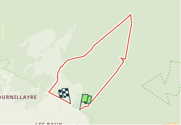

Length
7.3 km

Max alt
1028 m

Uphill gradient
544 m
Km-Effort
14.6 km

Min alt
442 m

Downhill gradient
578 m
Boucle
No
Creation date :
2021-09-08 08:58:28.445
Updated on :
2021-09-08 13:23:01.602
4h24
Difficulty : Medium

FREE GPS app for hiking
 SityTrail
IGN / Geographical institutes
SityTrail Plus
The world is yours!
About
Trail Walking of 7.3 km to be discovered at Provence-Alpes-Côte d'Azur, Vaucluse, Bédoin. This trail is proposed by Bernardb44.
Positioning
Country:
France
Region :
Provence-Alpes-Côte d'Azur
Department/Province :
Vaucluse
Municipality :
Bédoin
Location:
Unknown
Start:(Dec)
Start:(UTM)
678006 ; 4888544 (31T) N.
Comments