


Mondarrain urrezti

FERREREMARC
User
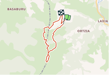

Length
6.9 km

Max alt
728 m

Uphill gradient
412 m
Km-Effort
12.5 km

Min alt
340 m

Downhill gradient
428 m
Boucle
No
Creation date :
2021-09-09 07:42:05.557
Updated on :
2021-09-09 10:50:27.592
3h07
Difficulty : Easy

FREE GPS app for hiking
 SityTrail
IGN / Geographical institutes
SityTrail Plus
The world is yours!
About
Trail Walking of 6.9 km to be discovered at New Aquitaine, Pyrénées-Atlantiques, Itxassou. This trail is proposed by FERREREMARC.
Positioning
Country:
France
Region :
New Aquitaine
Department/Province :
Pyrénées-Atlantiques
Municipality :
Itxassou
Location:
Unknown
Start:(Dec)
Start:(UTM)
627863 ; 4796619 (30T) N.
Comments