Trail On foot Ampuis - Le Recru - 9,8 km - 304 m de dénivelé - 3h30 - Photo

Le Recru - 9,8 km - 304 m de dénivelé - 3h30

© OpenStreetMap contributors
Length
Length
9.8 km
Max alt
Max alt
528 m
Uphill gradient
Uphill gradient
304 m
Km-Effort
Km-Effort  
13.8 km
Min alt
Min alt
327 m
Downhill gradient
Downhill gradient
304 m
Boucle
Boucle
Yes
Creation date :
2021-09-10 15:26:23.102
Updated on :
2023-10-26 12:40:37.196

(0 Reviews)

On foot
On foot
3h30
Difficulty : Medium

Scan this QR Code to open this trail in the SityTrail application

FREE GPS app for hiking

Logo SityTrail SityTrail

IGN / Geographical institutes

Download SityTrail from the App Store Download SityTrail from Google Play

Logo SityTrail SityTrail World

The world is yours!

Download SityTrail from the App Store Download SityTrail from Google Play Download SityTrail on Huawei AppGallery

About

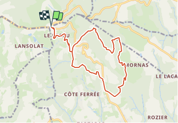
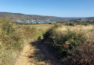
Trail On foot of 9.8 km to be discovered at Auvergne-Rhône-Alpes, Rhône, Ampuis. This trail is proposed by Clubléorando.

Description

Balade en boucle au départ du parking du hameau Le recru à l'intersection entre la D502 et la D45

Elevation profile

Positioning

Country:
France
Region :
Auvergne-Rhône-Alpes
Department/Province :
Rhône
Municipality :
Ampuis
Location:
Unknown
Start:(UTM)
638747 ; 5042718 (31T) N.

Trails nearby

Trail Walking Saint-Romain-en-Gal - le grisard - Photo
Walking
servemichel

Walking

Medium
(1)
Saint-Romain-en-Gal, Auvergne-Rhône-Alpes, Rhône, France
5.3 km | 7.9 km-effort
1h 48min
Yes
Trail Walking Échalas - 69-echalas-17km-450m - Photo
Walking
SyMA

Walking

Difficult
Échalas, Auvergne-Rhône-Alpes, Rhône, France
17.4 km | 23 km-effort
5h 17min
Yes
Trail Walking Loire-sur-Rhône - 69-loire-sur-rhone2-pet-de-loup-18km-560m - Photo
Walking
SyMA

Walking

Medium
(1)
Loire-sur-Rhône, Auvergne-Rhône-Alpes, Rhône, France
17.7 km | 25 km-effort
3h 3min
Yes
Trail Walking Loire-sur-Rhône - 69-Loire-sur-Rhone-17km-480m-avr22 - Photo
Walking
SyMA

Walking

Medium
Loire-sur-Rhône, Auvergne-Rhône-Alpes, Rhône, France
16.7 km | 23 km-effort
5h 9min
Yes
Trail On foot La Chapelle-Villars - Pilat N°30: des «Côteaux à les Haies» - Photo
On foot
PRO

On foot

Difficult
La Chapelle-Villars, Auvergne-Rhône-Alpes, Loire, France
29 km | 37 km-effort
8h 27min
Yes
Trail Walking Ampuis - AMPUIS JC - Photo
Walking
Clubléorando

Walking

Very easy
(1)
Ampuis, Auvergne-Rhône-Alpes, Rhône, France
9.7 km | 12.1 km-effort
3h 10min
Yes
Trail Walking Échalas - Rando à Echalas - Photo
Walking
tracegps

Walking

Medium
(1)
Échalas, Auvergne-Rhône-Alpes, Rhône, France
21 km | 29 km-effort
5h 0min
Yes
Trail Walking Loire-sur-Rhône - St romain x - Photo
Walking
alphonse22

Walking

Loire-sur-Rhône, Auvergne-Rhône-Alpes, Rhône, France
3.6 km | 5 km-effort
1h 57min
No
Trail Walking Reventin-Vaugris - Reventin - Photo
Walking
beaufortchop

Walking

Very easy
Reventin-Vaugris, Auvergne-Rhône-Alpes, Isère, France
2.7 km | 4.1 km-effort
45min
Yes


Close
My subscriptions