


2021-09-16_16h40m13_ribo_teanchel_-_up_and_down-9587564-1631802855-409

JulianeSCHAAL
User
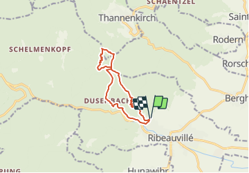

Length
10 km

Max alt
906 m

Uphill gradient
675 m
Km-Effort
19 km

Min alt
264 m

Downhill gradient
674 m
Boucle
Yes
Creation date :
2021-09-16 14:40:13.424
Updated on :
2021-09-16 14:40:14.971

FREE GPS app for hiking
 SityTrail
IGN / Geographical institutes
SityTrail Plus
The world is yours!
About
Trail of 10 km to be discovered at Grand Est, Haut-Rhin, Ribeauvillé. This trail is proposed by JulianeSCHAAL.
Positioning
Country:
France
Region :
Grand Est
Department/Province :
Haut-Rhin
Municipality :
Ribeauvillé
Location:
Unknown
Start:(Dec)
Start:(UTM)
374810 ; 5339778 (32U) N.
Comments
Randonnée sympa panoramique