


Belledonne AVF Prodin sommet Champotet

c.gourme
User
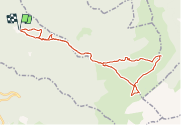

Length
13.2 km

Max alt
2073 m

Uphill gradient
887 m
Km-Effort
25 km

Min alt
1351 m

Downhill gradient
890 m
Boucle
Yes
Creation date :
2021-09-25 07:47:43.0
Updated on :
2021-09-26 19:36:40.269
5h08
Difficulty : Easy

FREE GPS app for hiking
 SityTrail
IGN / Geographical institutes
SityTrail Plus
The world is yours!
About
Trail Walking of 13.2 km to be discovered at Auvergne-Rhône-Alpes, Savoy, Presle. This trail is proposed by c.gourme.
Description
Enlever 60 m détour vers le col de la perche.
En voiture aller 1H15 par l'autoroute jusqu'à Pontchara puis aller au village Le Villard de la Table et prendre la route forestière de Prévieux 4km 20mn
Positioning
Country:
France
Region :
Auvergne-Rhône-Alpes
Department/Province :
Savoy
Municipality :
Presle
Location:
Unknown
Start:(Dec)
Start:(UTM)
278645 ; 5036233 (32T) N.
Comments