Trail Walking Emberménil - LES EVRIEUX - Photo
© OpenStreetMap contributors
Length
Length
6.5 km
Max alt
Max alt
324 m
Uphill gradient
Uphill gradient
95 m
Km-Effort
Km-Effort  
7.7 km
Min alt
Min alt
243 m
Downhill gradient
Downhill gradient
95 m
Boucle
Boucle
Yes
Creation date :
2021-09-26 06:56:37.763
Updated on :
2021-09-26 17:27:35.593

(0 Reviews)

Walking
Walking
2h00
Difficulty : Easy

Scan this QR Code to open this trail in the SityTrail application

FREE GPS app for hiking

Logo SityTrail SityTrail

IGN / Geographical institutes

Download SityTrail from the App Store Download SityTrail from Google Play

Logo SityTrail SityTrail World

The world is yours!

Download SityTrail from the App Store Download SityTrail from Google Play Download SityTrail on Huawei AppGallery

About

Trail Walking of 6.5 km to be discovered at Grand Est, Meurthe-et-Moselle, Emberménil. This trail is proposed by DanielROLLET.

Description

2021 09 16 - avec Marie - 09h00 à 11h00 - nombreux arrêts
Temps pluvieux mais calme
Reco pour CDSI ffRandonnée

Elevation profile

Positioning

Country:
France
Region :
Grand Est
Department/Province :
Meurthe-et-Moselle
Municipality :
Emberménil
Location:
Unknown
Start:(UTM)
330201 ; 5388828 (32U) N.

Trails nearby

Trail Walking Reillon - Reillon (Les Entonnoirs) - Photo
Walking
MMarie

Walking

Medium
Reillon, Grand Est, Meurthe-et-Moselle, France
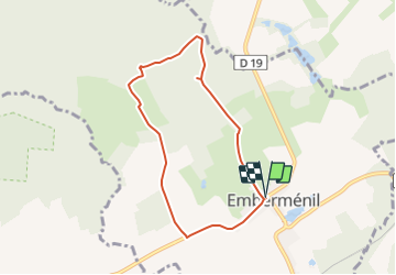
17.6 km | 21 km-effort
4h 27min
Yes
Trail Walking Reillon - Reillon, les Entonnoirs - Photo
Walking
reneperrin

Walking

Easy
Reillon, Grand Est, Meurthe-et-Moselle, France
8.1 km | 9.7 km-effort
1h 58min
Yes
Trail Walking Emberménil - Embermenil 6 470m +97m - Photo
Walking
DanielROLLET

Walking

Medium
Emberménil, Grand Est, Meurthe-et-Moselle, France
6.5 km | 7.8 km-effort
1h 45min
Yes
Trail Walking Vaucourt - vaucourt - Photo
Walking
didier cornelius

Walking

Difficult
Vaucourt, Grand Est, Meurthe-et-Moselle, France
10 km | 12.1 km-effort
2h 2min
Yes
Trail Walking Emberménil - Embermenil (Boucles des Entonnoirs) 21 040m +252m - Photo
Walking
DanielROLLET

Walking

Difficult
Emberménil, Grand Est, Meurthe-et-Moselle, France
21 km | 24 km-effort
6h 45min
Yes
Trail Walking Emberménil - Emberménil (Boucle Evrieux) 6 360m +96m - Photo
Walking
DanielROLLET

Walking

Medium
Emberménil, Grand Est, Meurthe-et-Moselle, France
6.4 km | 7.6 km-effort
1h 44min
Yes
Trail Walking Emberménil - entonnoir veho - Photo
Walking
msylviotte

Walking

Medium
Emberménil, Grand Est, Meurthe-et-Moselle, France
9.3 km | 11 km-effort
2h 3min
Yes
Trail Walking Emberménil - Emberménil (Les Boucles des Entonnoirs) 20 920m +253m - Photo
Walking
DanielROLLET

Walking

Medium
Emberménil, Grand Est, Meurthe-et-Moselle, France
21 km | 24 km-effort
5h 30min
Yes
Trail Horseback riding Vého - yujhgk - Photo
Horseback riding
ACPL

Horseback riding

Very easy
Vého, Grand Est, Meurthe-et-Moselle, France
12.1 km | 13.9 km-effort
2h 2min
Yes


Close
My subscriptions