Trail Walking Vaucourt - vaucourt - Photo
© OpenStreetMap contributors
Length
Length
10 km
Max alt
Max alt
294 m
Uphill gradient
Uphill gradient
160 m
Km-Effort
Km-Effort  
12.1 km
Min alt
Min alt
238 m
Downhill gradient
Downhill gradient
165 m
Boucle
Boucle
Yes
Creation date :
2022-04-15 11:07:11.277
Updated on :
2022-04-15 13:38:44.426

(0 Reviews)

Walking
Walking
2h02
Difficulty : Difficult

Scan this QR Code to open this trail in the SityTrail application

FREE GPS app for hiking

Logo SityTrail SityTrail

IGN / Geographical institutes

Download SityTrail from the App Store Download SityTrail from Google Play

Logo SityTrail SityTrail World

The world is yours!

Download SityTrail from the App Store Download SityTrail from Google Play Download SityTrail on Huawei AppGallery

About

Trail Walking of 10 km to be discovered at Grand Est, Meurthe-et-Moselle, Vaucourt. This trail is proposed by didier cornelius.

Description

l'aile des ours

Elevation profile

Positioning

Country:
France
Region :
Grand Est
Department/Province :
Meurthe-et-Moselle
Municipality :
Vaucourt
Location:
Unknown
Start:(UTM)
329724 ; 5392906 (32U) N.

Trails nearby

Trail Cycle Lagarde - Promenades fluviales, le vélo au fil de l'eau - Lagarde - Circuit 19 - 38 km - Photo
Cycle
tracegps

Cycle

Medium
Lagarde, Grand Est, Moselle, France
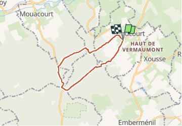
38 km | 43 km-effort
2h 30min
Yes
Trail Bicycle tourism Lagarde - 5ème jour vélo- Lagarde - Saverne 64km - Photo
Bicycle tourism
GUIDE
jeanmarcMasson

Bicycle tourism

Very difficult
Lagarde, Grand Est, Moselle, France
65 km | 72 km-effort
4h 26min
No
Trail Walking Emberménil - Embermenil 6 470m +97m - Photo
Walking
DanielROLLET

Walking

Medium
Emberménil, Grand Est, Meurthe-et-Moselle, France
6.5 km | 7.8 km-effort
1h 45min
Yes
Trail Walking Lagarde - lagarde - Photo
Walking
didier cornelius

Walking

Easy
Lagarde, Grand Est, Moselle, France
10.7 km | 12.2 km-effort
2h 52min
Yes
Trail Walking Lagarde - Lagarde  - Photo
Walking
didier cornelius

Walking

Easy
Lagarde, Grand Est, Moselle, France
9.9 km | 11.4 km-effort
2h 8min
Yes
Trail Walking Emberménil - Embermenil (Boucles des Entonnoirs) 21 040m +252m - Photo
Walking
DanielROLLET

Walking

Difficult
Emberménil, Grand Est, Meurthe-et-Moselle, France
21 km | 24 km-effort
6h 45min
Yes
Trail Walking Emberménil - LES EVRIEUX - Photo
Walking
DanielROLLET

Walking

Easy
Emberménil, Grand Est, Meurthe-et-Moselle, France
6.5 km | 7.7 km-effort
2h 0min
Yes
Trail Cycle Lagarde - Promenades fluviales, le vélo au fil de l'eau - Lagarde - Circuit 19 - 30 km - Photo
Cycle
tracegps

Cycle

Medium
Lagarde, Grand Est, Moselle, France
29 km | 34 km-effort
1h 30min
Yes
Trail Walking Emberménil - Emberménil (Boucle Evrieux) 6 360m +96m - Photo
Walking
DanielROLLET

Walking

Medium
Emberménil, Grand Est, Meurthe-et-Moselle, France
6.4 km | 7.6 km-effort
1h 44min
Yes


Close
My subscriptions