


lac et col des Cerces

laurentnecca
User
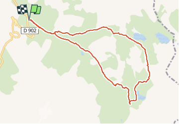

Length
10.2 km

Max alt
2583 m

Uphill gradient
625 m
Km-Effort
18.5 km

Min alt
1968 m

Downhill gradient
621 m
Boucle
Yes
Creation date :
2021-10-02 07:53:10.679
Updated on :
2021-10-02 12:54:43.858
3h41
Difficulty : Medium

FREE GPS app for hiking
 SityTrail
IGN / Geographical institutes
SityTrail Plus
The world is yours!
About
Trail Walking of 10.2 km to be discovered at Auvergne-Rhône-Alpes, Savoy, Valloire. This trail is proposed by laurentnecca.
Photos


Positioning
Country:
France
Region :
Auvergne-Rhône-Alpes
Department/Province :
Savoy
Municipality :
Valloire
Location:
Unknown
Start:(Dec)
Start:(UTM)
298218 ; 4996128 (32T) N.
Comments