


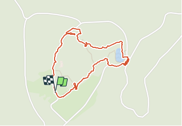
Mont Bessou tit tour fait

pidjam
User

Length
2.3 km

Max alt
979 m

Uphill gradient
60 m
Km-Effort
3.1 km

Min alt
921 m

Downhill gradient
53 m
Boucle
Yes
Creation date :
2021-10-02 11:49:08.331
Updated on :
2021-10-07 09:47:29.053
1h09
Difficulty : Easy

FREE GPS app for hiking
 SityTrail
IGN / Geographical institutes
SityTrail Plus
The world is yours!
About
Trail Walking of 2.3 km to be discovered at New Aquitaine, Corrèze, Meymac. This trail is proposed by pidjam.
Positioning
Country:
France
Region :
New Aquitaine
Department/Province :
Corrèze
Municipality :
Meymac
Location:
Unknown
Start:(Dec)
Start:(UTM)
431544 ; 5046507 (31T) N.
Comments