


Tourbières fait

pidjam
User
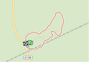

Length
900 m

Max alt
902 m

Uphill gradient
22 m
Km-Effort
1.2 km

Min alt
874 m

Downhill gradient
25 m
Boucle
Yes
Creation date :
2021-10-02 13:20:09.361
Updated on :
2021-10-07 09:47:32.698
24m
Difficulty : Easy

FREE GPS app for hiking
 SityTrail
IGN / Geographical institutes
SityTrail Plus
The world is yours!
About
Trail Walking of 900 m to be discovered at New Aquitaine, Corrèze, Saint-Merd-les-Oussines. This trail is proposed by pidjam.
Positioning
Country:
France
Region :
New Aquitaine
Department/Province :
Corrèze
Municipality :
Saint-Merd-les-Oussines
Location:
Unknown
Start:(Dec)
Start:(UTM)
427479 ; 5049731 (31T) N.
Comments