


rando VTT du 10/10 avec Lolo

dudu79
User
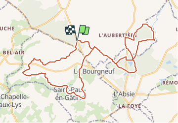

Length
26 km

Max alt
232 m

Uphill gradient
398 m
Km-Effort
32 km

Min alt
146 m

Downhill gradient
402 m
Boucle
Yes
Creation date :
2021-10-10 05:22:49.923
Updated on :
2021-10-10 05:22:52.251
2h12
Difficulty : Medium

FREE GPS app for hiking
 SityTrail
IGN / Geographical institutes
SityTrail Plus
The world is yours!
About
Trail Mountain bike of 26 km to be discovered at New Aquitaine, Deux-Sèvres, Moncoutant-sur-Sèvre. This trail is proposed by dudu79.
Positioning
Country:
France
Region :
New Aquitaine
Department/Province :
Deux-Sèvres
Municipality :
Moncoutant-sur-Sèvre
Location:
La Chapelle-Saint-Étienne
Start:(Dec)
Start:(UTM)
682851 ; 5169934 (30T) N.
Comments