Trail Walking Saint-Jorioz - Saint Jorioz - Boucle du Laudon  - Photo

Saint Jorioz - Boucle du Laudon

 Kargil
Kargil

User GUIDE

© OpenStreetMap contributors
Length
Length
13.2 km
Max alt
Max alt
747 m
Uphill gradient
Uphill gradient
426 m
Km-Effort
Km-Effort  
18.9 km
Min alt
Min alt
471 m
Downhill gradient
Downhill gradient
427 m
Boucle
Boucle
Yes
Creation date :
2021-10-10 07:45:18.837
Updated on :
2021-10-11 11:05:24.351

(0 Reviews)

Walking
Walking
3h13
Difficulty : Easy

Scan this QR Code to open this trail in the SityTrail application

FREE GPS app for hiking

Logo SityTrail SityTrail

IGN / Geographical institutes

Download SityTrail from the App Store Download SityTrail from Google Play

Logo SityTrail SityTrail World

The world is yours!

Download SityTrail from the App Store Download SityTrail from Google Play Download SityTrail on Huawei AppGallery

About

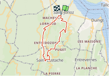
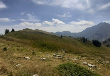
Trail Walking of 13.2 km to be discovered at Auvergne-Rhône-Alpes, Upper Savoy, Saint-Jorioz. This trail is proposed by Kargil.

Description

Sentier nature que l'on pourrait nommer le sentier des châtaigniers tant il y en a.
Quelques beau prés à champignons et tout une partie en sous bois le long des ruisseaux
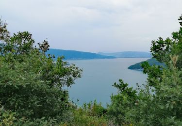
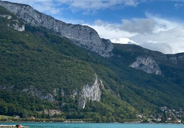
Un seul bémol, un seul panorama sur le lac d'Annecy.
La tournette est plus visible mais ce jour elle avait mis son bonnet de nuages dû à la fraicheur automnale

Elevation profile

Photos

Points of interest

Point of interest Saint-Eustache - Unnamed POI - Photo
Kargil
SAINT-EUSTACHE 
Point of interest Saint-Eustache - Unnamed POI - Photo
Kargil
SAINT-EUSTACHE 
Point of interest Saint-Jorioz - Unnamed POI - Photo
Kargil
SAINT-JORIOZ 

Positioning

Country:
France
Region :
Auvergne-Rhône-Alpes
Department/Province :
Upper Savoy
Municipality :
Saint-Jorioz
Location:
Unknown
Start:(UTM)
279525 ; 5079230 (32T) N.

Trails nearby

Trail Mountain bike Lathuile - VTT des sources du lac d'Annecy - Photo
Mountain bike
GUIDE
pascalou73

Mountain bike

Medium
(2)
Lathuile, Auvergne-Rhône-Alpes, Upper Savoy, France
27 km | 31 km-effort
2h 3min
Yes
Trail Walking Duingt - Montagne d'Entrevernes - Photo
Walking
gebocarm

Walking

Medium
(2)
Duingt, Auvergne-Rhône-Alpes, Upper Savoy, France
9.6 km | 19.3 km-effort
3h 53min
Yes
Trail Walking Talloires-Montmin - Talloires ermitage  - Photo
Walking
GUIDE
HERRY

Walking

Talloires-Montmin, Auvergne-Rhône-Alpes, Upper Savoy, France
7 km | 11.8 km-effort
2h 5min
Yes
Trail Cycle Lathuile - Le tour du lac d'Annecy - Photo
Cycle
GUIDE
pascalou73

Cycle

Easy
Lathuile, Auvergne-Rhône-Alpes, Upper Savoy, France
38 km | 45 km-effort
2h 28min
No
Trail Walking Talloires-Montmin - Annecy - Photo
Walking
fredo155

Walking

Difficult
Talloires-Montmin, Auvergne-Rhône-Alpes, Upper Savoy, France
10.4 km | 14.2 km-effort
2h 53min
Yes
Trail Walking Duingt - Boucle du Taillefer - Photo
Walking
GUIDE
affinetataille

Walking

Medium
Duingt, Auvergne-Rhône-Alpes, Upper Savoy, France
11.3 km | 17.6 km-effort
4h 0min
Yes
Trail Walking Talloires-Montmin - BORNES: UN PEU DE DENIVELE AU DEPART DE PLANFAIT - Photo
Walking
djeepee74

Walking

Difficult
Talloires-Montmin, Auvergne-Rhône-Alpes, Upper Savoy, France
16.6 km | 35 km-effort
5h 23min
Yes
Trail Walking Duingt - Montagne de Taillefer - Photo
Walking
GUIDE+

Walking

Easy
(1)
Duingt, Auvergne-Rhône-Alpes, Upper Savoy, France
3.2 km | 5.9 km-effort
1h 20min
Yes
Trail Road bike Saint-Jorioz - Tour du Lac d’Annecy - Photo
Road bike
pauldurand

Road bike

Easy
Saint-Jorioz, Auvergne-Rhône-Alpes, Upper Savoy, France
39 km | 46 km-effort
2h 48min
Yes


Close
My subscriptions