


le peynet

lionelnottat
User
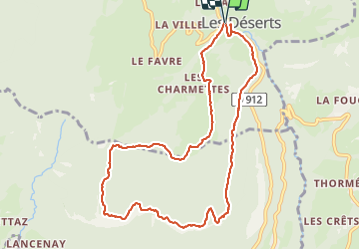

Length
10.7 km

Max alt
1349 m

Uphill gradient
530 m
Km-Effort
17.8 km

Min alt
908 m

Downhill gradient
528 m
Boucle
Yes
Creation date :
2021-10-12 07:31:06.284
Updated on :
2021-10-12 13:01:18.504
3h16
Difficulty : Difficult

FREE GPS app for hiking
 SityTrail
IGN / Geographical institutes
SityTrail Plus
The world is yours!
About
Trail Walking of 10.7 km to be discovered at Auvergne-Rhône-Alpes, Savoy, Les Déserts. This trail is proposed by lionelnottat.
Positioning
Country:
France
Region :
Auvergne-Rhône-Alpes
Department/Province :
Savoy
Municipality :
Les Déserts
Location:
Unknown
Start:(Dec)
Start:(UTM)
266794 ; 5056279 (32T) N.
Comments