


Lac vert 4 déc. 2019

Nordic33
User GUIDE
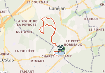

Length
6.9 km

Max alt
62 m

Uphill gradient
62 m
Km-Effort
7.7 km

Min alt
33 m

Downhill gradient
62 m
Boucle
No
Creation date :
2021-10-13 12:27:28.068
Updated on :
2021-10-17 07:10:35.312
--
Difficulty : Very easy

FREE GPS app for hiking
 SityTrail
IGN / Geographical institutes
SityTrail Plus
The world is yours!
About
Trail Nordic walking of 6.9 km to be discovered at New Aquitaine, Gironde, Canéjan. This trail is proposed by Nordic33.
Positioning
Country:
France
Region :
New Aquitaine
Department/Province :
Gironde
Municipality :
Canéjan
Location:
Unknown
Start:(Dec)
Start:(UTM)
685740 ; 4957076 (30T) N.
Comments