Trail On foot Peyrelevade - GR440, jour 6 Lieu de bivouac à Lieu de bivouac sommet herbeux - Photo

GR440, jour 6 Lieu de bivouac à Lieu de bivouac sommet herbeux

© OpenStreetMap contributors
Length
Length
26 km
Max alt
Max alt
951 m
Uphill gradient
Uphill gradient
593 m
Km-Effort
Km-Effort  
33 km
Min alt
Min alt
756 m
Downhill gradient
Downhill gradient
483 m
Boucle
Boucle
No
Creation date :
2021-10-14 09:40:08.377
Updated on :
2021-10-14 09:49:43.985

(0 Reviews)

On foot
On foot
30m
Difficulty : Easy

Scan this QR Code to open this trail in the SityTrail application

FREE GPS app for hiking

Logo SityTrail SityTrail

IGN / Geographical institutes

Download SityTrail from the App Store Download SityTrail from Google Play

Logo SityTrail SityTrail Plus

The world is yours!

Download SityTrail from the App Store Download SityTrail from Google Play Download SityTrail on Huawei AppGallery

About

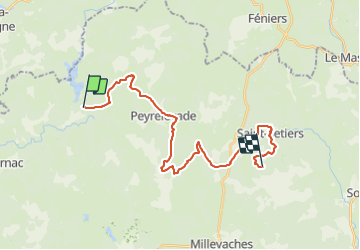
Trail On foot of 26 km to be discovered at New Aquitaine, Corrèze, Peyrelevade. This trail is proposed by MathieuBourgois.

Description

-Altitude max 951
-Ludinas 1.7km et 50D
-Négarioux 4km et 80D
-Peyrelevade 7.3km et 160D
-Croisement D36 18km et 450D
-Saint-Setiers 22km et 500D
-Sounaleix 25km et 580D
-Lieu de bivouac, sommet herbeux 26km et 590D

Elevation profile

Positioning

Country:
France
Region :
New Aquitaine
Department/Province :
Corrèze
Municipality :
Peyrelevade
Location:
Unknown
Start:(UTM)
422150 ; 5062056 (31T) N.


Close
My subscriptions