


Castelnou R3

Phidel66
User
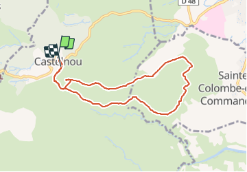

Length
9.1 km

Max alt
438 m

Uphill gradient
371 m
Km-Effort
14 km

Min alt
201 m

Downhill gradient
363 m
Boucle
Yes
Creation date :
2021-10-14 12:03:54.075
Updated on :
2021-10-14 16:21:46.825
4h17
Difficulty : Difficult

FREE GPS app for hiking
 SityTrail
IGN / Geographical institutes
SityTrail Plus
The world is yours!
About
Trail Walking of 9.1 km to be discovered at Occitania, Pyrénées-Orientales, Castelnou. This trail is proposed by Phidel66.
Description
romarin
Positioning
Country:
France
Region :
Occitania
Department/Province :
Pyrénées-Orientales
Municipality :
Castelnou
Location:
Unknown
Start:(Dec)
Start:(UTM)
475653 ; 4718671 (31T) N.
Comments