Trail Walking Chamrousse - Croix de Chamrousse - Photo
 flip38
flip38

User

© OpenStreetMap contributors
Length
Length
17.7 km
Max alt
Max alt
2251 m
Uphill gradient
Uphill gradient
864 m
Km-Effort
Km-Effort  
29 km
Min alt
Min alt
1640 m
Downhill gradient
Downhill gradient
865 m
Boucle
Boucle
Yes
Creation date :
2021-10-17 10:06:29.746
Updated on :
2021-10-31 10:35:46.287

(0 Reviews)

Walking
Walking
6h18
Difficulty : Difficult

Scan this QR Code to open this trail in the SityTrail application

FREE GPS app for hiking

Logo SityTrail SityTrail

IGN / Geographical institutes

Download SityTrail from the App Store Download SityTrail from Google Play

Logo SityTrail SityTrail World

The world is yours!

Download SityTrail from the App Store Download SityTrail from Google Play Download SityTrail on Huawei AppGallery

About

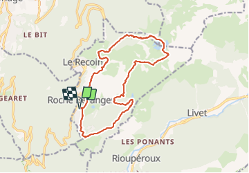
Trail Walking of 17.7 km to be discovered at Auvergne-Rhône-Alpes, Isère, Chamrousse. This trail is proposed by flip38.

Description

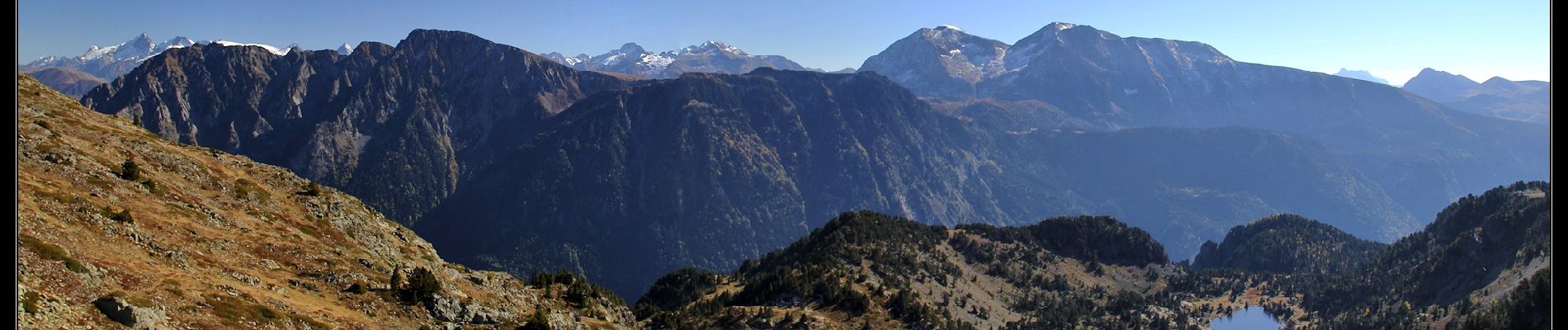
Belle boucle automnale vers le sommet de la Croix de Chamrousse.
Visite des lacs du coin et un beau panorama, même si on traverse en partie les pistes de la station de Chamrousse.

D'autres informations sur mon site : http://surlessommets.blog.free.fr/

Elevation profile

Photos

Positioning

Country:
France
Region :
Auvergne-Rhône-Alpes
Department/Province :
Isère
Municipality :
Chamrousse
Location:
Unknown
Start:(UTM)
726209 ; 4999161 (31T) N.

Trails nearby

Trail Walking Chamrousse - Boucle Roche Béranger - lacs Robert - Chamrousse - Photo
Walking
tracegps

Walking

Medium
(1)
Chamrousse, Auvergne-Rhône-Alpes, Isère, France
11.4 km | 20 km-effort
4h 30min
Yes
Trail On foot Saint-Martin-d'Uriage - Circuit des Curistes - Photo
On foot
PRO

On foot

Easy
Saint-Martin-d'Uriage, Auvergne-Rhône-Alpes, Isère, France
5.9 km | 7.8 km-effort
1h 46min
Yes
Trail On foot Saint-Martin-d'Uriage - Circuit des Crêtes - Photo
On foot
PRO

On foot

Easy
Saint-Martin-d'Uriage, Auvergne-Rhône-Alpes, Isère, France
9.5 km | 13.6 km-effort
3h 5min
Yes
Trail On foot Saint-Martin-d'Uriage - Circuit du Bit - Photo
On foot
PRO

On foot

Easy
Saint-Martin-d'Uriage, Auvergne-Rhône-Alpes, Isère, France
9.1 km | 16.3 km-effort
3h 41min
Yes
Trail Walking Chamrousse - lacs Robert  - Photo
Walking
marshall44

Walking

Medium
(1)
Chamrousse, Auvergne-Rhône-Alpes, Isère, France
9.2 km | 21 km-effort
5h 0min
Yes
Trail Walking Vaulnaveys-le-Haut - col de la botte - Photo
Walking
Youcef Atallah

Walking

Very difficult
Vaulnaveys-le-Haut, Auvergne-Rhône-Alpes, Isère, France
11 km | 19.4 km-effort
3h 3min
No
Trail Touring skiing Chamrousse - col de la petite vaudaine - Photo
Touring skiing
nadd73

Touring skiing

Medium
Chamrousse, Auvergne-Rhône-Alpes, Isère, France
15.4 km | 35 km-effort
7h 7min
Yes
Trail Walking Vaulnaveys-le-Bas - Montchaffrey/chartreuse de premol - Photo
Walking
Youcef Atallah

Walking

Very difficult
Vaulnaveys-le-Bas, Auvergne-Rhône-Alpes, Isère, France
15 km | 23 km-effort
3h 54min
Yes
Trail Walking Chamrousse - Croix de Chamrousse depuis l'Arselle - Photo
Walking
GuyVachet

Walking

Difficult
Chamrousse, Auvergne-Rhône-Alpes, Isère, France
11 km | 19.5 km-effort
5h 44min
Yes


Close
My subscriptions