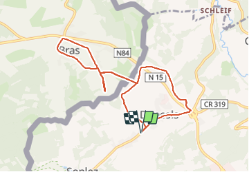
Trail Walking Winseler - 20211017 - Doncols 8.4 Km - Photo

20211017 - Doncols 8.4 Km

 pierreh01
pierreh01

User GUIDE

© OpenStreetMap contributors
Length
Length
8.3 km
Max alt
Max alt
524 m
Uphill gradient
Uphill gradient
140 m
Km-Effort
Km-Effort  
10.2 km
Min alt
Min alt
449 m
Downhill gradient
Downhill gradient
140 m
Boucle
Boucle
Yes
Creation date :
17/10/2021 08:56
Updated on :
17/10/2021 18:30

(0 Reviews)

Walking
Walking
2h11
Difficulty : Medium

Scan this QR Code to open this trail in the SityTrail application

FREE GPS app for hiking

Logo SityTrail SityTrail

IGN / Geographical institutes

Download SityTrail from the App Store Download SityTrail from Google Play

Logo SityTrail SityTrail Plus

The world is yours!

Download SityTrail from the App Store Download SityTrail from Google Play Download SityTrail on Huawei AppGallery

About

Trail Walking of 8.3 km to be discovered at Unknown, Canton Wiltz, Winseler. This trail is proposed by pierreh01.

Description

Dimanche 17 octobre 2021 : Retrouvailles des "Moniteurs Mutu" à DONCOLS (Luxembourg)
Balade sous une météo agréable dans les environs de Doncols et frontière belge.
Circuit modifié à cause de chasse à cette date, dans les bois que l'on aurait du traverser.

Elevation profile

Photos

Positioning

Country:
Luxembourg
Region :
Unknown
Department/Province :
Canton Wiltz
Municipality :
Winseler
Location:
Unknown
Start:(UTM)
703531 ; 5539206 (31U) N.


Close
My subscriptions