Trail Walking Frontenas - Frontenas (Rhône) 12 km - D. 167 m - Photo

Frontenas (Rhône) 12 km - D. 167 m

© OpenStreetMap contributors
Length
Length
11.6 km
Max alt
Max alt
376 m
Uphill gradient
Uphill gradient
167 m
Km-Effort
Km-Effort  
13.8 km
Min alt
Min alt
285 m
Downhill gradient
Downhill gradient
166 m
Boucle
Boucle
Yes
Creation date :
2021-10-21 11:59:09.0
Updated on :
2021-11-08 16:55:48.082

(0 Reviews)

Walking
Walking
3h02
Difficulty : Easy

Scan this QR Code to open this trail in the SityTrail application

FREE GPS app for hiking

Logo SityTrail SityTrail

IGN / Geographical institutes

Download SityTrail from the App Store Download SityTrail from Google Play

Logo SityTrail SityTrail World

The world is yours!

Download SityTrail from the App Store Download SityTrail from Google Play Download SityTrail on Huawei AppGallery

About

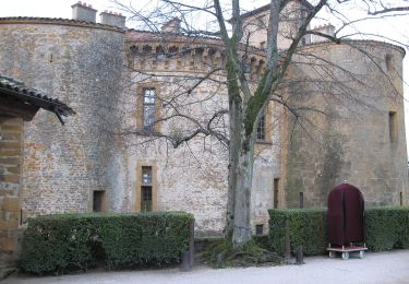
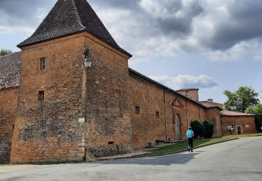
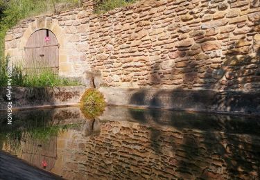
Trail Walking of 11.6 km to be discovered at Auvergne-Rhône-Alpes, Rhône, Frontenas. This trail is proposed by Thomasdanielle.

Description

D/A : Parking rue de la Force, proche du lavoir
Randonnée sans difficulté, réalisée le 21/10/2021.

Elevation profile

Positioning

Country:
France
Region :
Auvergne-Rhône-Alpes
Department/Province :
Rhône
Municipality :
Frontenas
Location:
Unknown
Start:(UTM)
625492 ; 5086895 (31T) N.

Trails nearby

Trail Walking Val d'Oingt - Oingt (69) Beaujolais  - Photo
Walking
Thomasdanielle

Walking

Very easy
(1)
Val d'Oingt, Auvergne-Rhône-Alpes, Rhône, France
9.3 km | 13.3 km-effort
2h 30min
Yes
Trail On foot Légny - De Saint Vérand à Bagnols - Photo
On foot
PRO

On foot

Easy
Légny, Auvergne-Rhône-Alpes, Rhône, France
7.4 km | 10.3 km-effort
2h 20min
No
Trail On foot Saint-Jean-des-Vignes - De Bagnols à Lozanne - Photo
On foot
PRO

On foot

Easy
Saint-Jean-des-Vignes, Auvergne-Rhône-Alpes, Rhône, France
4 km | 5 km-effort
1h 7min
No
Trail Nordic walking Bagnols - bagnol - Photo
Nordic walking
isabelle.xavier

Nordic walking

Very easy
(1)
Bagnols, Auvergne-Rhône-Alpes, Rhône, France
6.8 km | 8.4 km-effort
1h 40min
Yes
Trail Electric bike Val d'Oingt - tour dans le beaujolais Oingt - Salles sur Arbuissonnas - Photo
Electric bike
cailloux54

Electric bike

Medium
(1)
Val d'Oingt, Auvergne-Rhône-Alpes, Rhône, France
52 km | 68 km-effort
5h 44min
Yes
Trail Walking Sainte-Paule - Sainte-Paule (13,4 km D. 485 m) - Photo
Walking
Thomasdanielle

Walking

Medium
(1)
Sainte-Paule, Auvergne-Rhône-Alpes, Rhône, France
13.4 km | 19.4 km-effort
4h 9min
Yes
Trail Walking Chessy - Chessy à Bagnols - Photo
Walking
Jean-Marc C

Walking

Difficult
(1)
Chessy, Auvergne-Rhône-Alpes, Rhône, France
12.5 km | 15.8 km-effort
3h 35min
Yes
Trail Walking Val d'Oingt - Saint-Laurent d'Oingt - Oingt, Plus beau Village de France - Photo
Walking
adye

Walking

Difficult
Val d'Oingt, Auvergne-Rhône-Alpes, Rhône, France
8.8 km | 12.5 km-effort
2h 20min
Yes
Trail Walking Val d'Oingt - 69620-Saint-Laurent d'Oingt-Bois d'Oingt : lavoirs, château et coteaux - Photo
Walking
adye

Walking

Medium
Val d'Oingt, Auvergne-Rhône-Alpes, Rhône, France
8 km | 11 km-effort
1h 57min
Yes


Close
My subscriptions