


thann rangen

jcschubnel
User
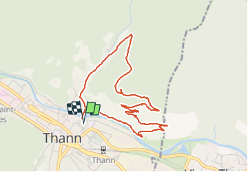

Length
4.9 km

Max alt
502 m

Uphill gradient
191 m
Km-Effort
7.4 km

Min alt
331 m

Downhill gradient
191 m
Boucle
Yes
Creation date :
2021-10-22 12:07:42.857
Updated on :
2021-10-22 22:21:14.221
2h44
Difficulty : Medium

FREE GPS app for hiking
 SityTrail
IGN / Geographical institutes
SityTrail Plus
The world is yours!
About
Trail Walking of 4.9 km to be discovered at Grand Est, Haut-Rhin, Thann. This trail is proposed by jcschubnel.
Positioning
Country:
France
Region :
Grand Est
Department/Province :
Haut-Rhin
Municipality :
Thann
Location:
Unknown
Start:(Dec)
Start:(UTM)
358117 ; 5297058 (32T) N.
Comments