![](/images/other/stat-length.png)
![Trail Walking Balbigny - rando au départ de Balbigny, viaduc Chessieu, St Georges de Barolles, les Sigauds, Grenieux, Nervieux, Pont de Balbigny - Photo](https://media.geolcdn.com/t/1900/400/ext.pjpeg?maxdim=2&url=https%3A%2F%2Fmedia.geolcdn.com%2Ff%2F5db3212e-40b4-459c-9353-6a43c13d12c3.jpg)
rando au départ de Balbigny, viaduc Chessieu, St Georges de Barolles, les Sigauds, Grenieux, Nervieux, Pont de Balbigny
mimi69670
User
![Length](/images/other/stat-length.png)
Length
18.1 km
![Max alt](https://static1.geolcdn.com/siteimages/upload/files/1508320355ic_sort_altitude_max_24dp.png)
Max alt
392 m
![Uphill gradient](https://static1.geolcdn.com/siteimages/upload/files/1508320355ic_sort_den_pos_24dp.png)
Uphill gradient
221 m
![Km-Effort](/images/other/stat-length.png)
Km-Effort
21 km
![Min alt](https://static1.geolcdn.com/siteimages/upload/files/1508320355ic_sort_altitude_min_24dp.png)
Min alt
314 m
![Downhill gradient](https://static1.geolcdn.com/siteimages/upload/files/1508320355ic_sort_den_neg_24dp.png)
Downhill gradient
220 m
![Boucle](https://static1.geolcdn.com/siteimages/upload/files/16400158638029165_repeat_loop_refresh_sync_direction_icon.png)
Boucle
Yes
Creation date :
2021-10-24 12:25:04.992
Updated on :
2021-10-24 17:08:13.424
![Walking](https://static1.geolcdn.com/sitytour/trail-icons/101.png)
3h50
Difficulty : Easy
![Scan this QR Code to open this trail in the SityTrail application](https://capi.geolives.com/qq0zvz2zws4bq2lad0pu/sitytour/trails/2981502/qr.png?size=200)
FREE GPS app for hiking
About
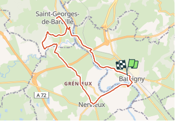
Trail Walking of 18.1 km to be discovered at Auvergne-Rhône-Alpes, Loire, Balbigny. This trail is proposed by mimi69670.
Description
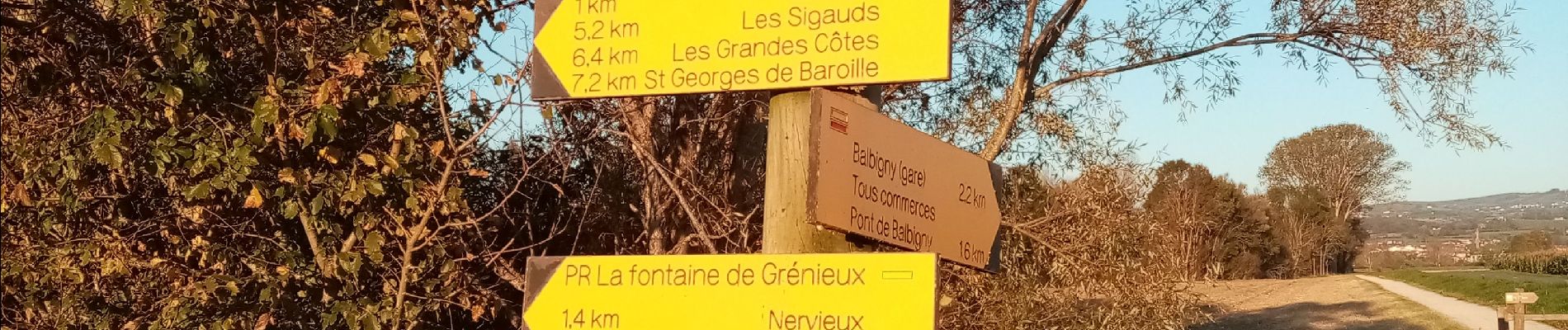
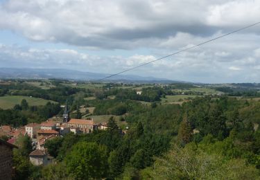
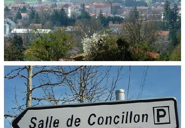
Départ de gammvert de Balbigny, viaduc de Chessieu par les bords de la Loire, St Georges des Barolles, Les Sigauds, Grenieux, Nervieux, arrivée vers le pont de Balbigny
Positioning
Country:
France
Region :
Auvergne-Rhône-Alpes
Department/Province :
Loire
Municipality :
Balbigny
Location:
Unknown
Start:(Dec)
Start:(UTM)
591632 ; 5074823 (31T) N.
Comments
Trails nearby
![Trail Walking Néronde - Néronde - Photo](https://media.geolcdn.com/t/375/260/ext.jpg?maxdim=2&url=https%3A%2F%2Fmedia.geolcdn.com%2Ff%2F6bde23c5-3f50-4a5f-9ffc-209933c94287.JPG)
![Walking Walking](https://static1.geolcdn.com/sitytour/trail-icons/101.png)
Néronde
Walking
Medium
(1)
Néronde,
Auvergne-Rhône-Alpes,
Loire,
France
![](/images/other/stat-length.png)
11.4 km | 15.3 km-effort
4h 12min
![](https://static1.geolcdn.com/siteimages/upload/files/16400158638029165_repeat_loop_refresh_sync_direction_icon.png)
Yes
![Trail Walking Balbigny - Autour des Gorges de la Loire - PR N° 2 : Le Funiculaire de Biesse - Les Chessieux - Photo](https://media.geolcdn.com/t/375/260/ext.jpg?maxdim=2&url=https%3A%2F%2Fservices.sitytrail.com%2FGeolivesWS%2FDownloadMedia.ashx%3FTrailID%3D215160%26Media%3D15762_6.jpg)
![Walking Walking](https://static1.geolcdn.com/sitytour/trail-icons/101.png)
Autour des Gorges de la Loire - PR N° 2 : Le Funiculaire de Biesse - Les Ches...
Walking
Medium
(1)
Balbigny,
Auvergne-Rhône-Alpes,
Loire,
France
![](/images/other/stat-length.png)
8.7 km | 11 km-effort
3h 0min
![](https://static1.geolcdn.com/siteimages/upload/files/16400158638029165_repeat_loop_refresh_sync_direction_icon.png)
Yes
![Trail Mountain bike Balbigny - B6 - VTT Montagnes du Matin - Balbigny - Photo](https://media.geolcdn.com/t/375/260/ext.jpg?maxdim=2&url=https%3A%2F%2Fservices.sitytrail.com%2FGeolivesWS%2FDownloadMedia.ashx%3FTrailID%3D172328%26Media%3D13651_6.jpg)
![Mountain bike Mountain bike](https://static1.geolcdn.com/sitytour/trail-icons/202.png)
B6 - VTT Montagnes du Matin - Balbigny
Mountain bike
Difficult
(1)
Balbigny,
Auvergne-Rhône-Alpes,
Loire,
France
![](/images/other/stat-length.png)
17.6 km | 22 km-effort
2h 0min
![](https://static1.geolcdn.com/siteimages/upload/files/16400158638029165_repeat_loop_refresh_sync_direction_icon.png)
Yes
![Trail Walking Néronde - Néronde - Pouilly les Feurs - Photo](https://media.geolcdn.com/t/375/260/ext.jpg?maxdim=2&url=https%3A%2F%2Fstatic1.geolcdn.com%2Fsiteimages%2Fupload%2Ffiles%2F1553511878bg_sport_marche.png)
![Walking Walking](https://static1.geolcdn.com/sitytour/trail-icons/101.png)
Néronde - Pouilly les Feurs
Walking
Very difficult
(1)
Néronde,
Auvergne-Rhône-Alpes,
Loire,
France
![](/images/other/stat-length.png)
18.4 km | 25 km-effort
5h 46min
![](https://static1.geolcdn.com/siteimages/upload/files/16400158638029165_repeat_loop_refresh_sync_direction_icon.png)
Yes
![Trail Walking Pouilly-lès-Feurs - Randonnée de Pouilly les Feurs - Photo](https://media.geolcdn.com/t/375/260/ext.jpg?maxdim=2&url=https%3A%2F%2Fmedia.geolcdn.com%2Ff%2F0f77cdd6-65d8-41be-b44b-39fa6456f5ec.jpg)
![Walking Walking](https://static1.geolcdn.com/sitytour/trail-icons/101.png)
Randonnée de Pouilly les Feurs
Walking
Medium
Pouilly-lès-Feurs,
Auvergne-Rhône-Alpes,
Loire,
France
![](/images/other/stat-length.png)
16.2 km | 21 km-effort
3h 27min
![](https://static1.geolcdn.com/siteimages/upload/files/16400158638029165_repeat_loop_refresh_sync_direction_icon.png)
Yes
![Trail Walking Mizérieux - Mizerieux - Photo](https://media.geolcdn.com/t/375/260/ext.jpg?maxdim=2&url=https%3A%2F%2Fstatic1.geolcdn.com%2Fsiteimages%2Fupload%2Ffiles%2F1553511878bg_sport_marche.png)
![Walking Walking](https://static1.geolcdn.com/sitytour/trail-icons/101.png)
Mizerieux
Walking
Easy
(1)
Mizérieux,
Auvergne-Rhône-Alpes,
Loire,
France
![](/images/other/stat-length.png)
8.6 km | 9.6 km-effort
1h 39min
![](https://static1.geolcdn.com/siteimages/upload/files/16400158638029165_repeat_loop_refresh_sync_direction_icon.png)
Yes
![Trail Walking Mizérieux - Mizerieux, les grands Chambons - Photo](https://media.geolcdn.com/t/375/260/ext.jpg?maxdim=2&url=https%3A%2F%2Fmedia.geolcdn.com%2Ff%2F411c1e0d-db77-493e-a8ae-e8ad36add8e4.jpg)
![Walking Walking](https://static1.geolcdn.com/sitytour/trail-icons/101.png)
Mizerieux, les grands Chambons
Walking
Very easy
Mizérieux,
Auvergne-Rhône-Alpes,
Loire,
France
![](/images/other/stat-length.png)
11.1 km | 11.8 km-effort
3h 0min
![](https://static1.geolcdn.com/siteimages/upload/files/16400158638029165_repeat_loop_refresh_sync_direction_icon.png)
Yes
![Trail Walking Balbigny - départ de carrefour market Balbigny, les Chessieu, le Chatelard, la digue de Pinay, retour sur Balbigny - Photo](https://media.geolcdn.com/t/375/260/ext.jpg?maxdim=2&url=https%3A%2F%2Fmedia.geolcdn.com%2Ff%2F471fef2b-1bad-4105-ac34-0aa84a5add34.jpg)
![Walking Walking](https://static1.geolcdn.com/sitytour/trail-icons/101.png)
départ de carrefour market Balbigny, les Chessieu, le Chatelard, la digue de ...
Walking
Easy
Balbigny,
Auvergne-Rhône-Alpes,
Loire,
France
![](/images/other/stat-length.png)
17.1 km | 21 km-effort
4h 37min
![](https://static1.geolcdn.com/siteimages/upload/files/16400158638029165_repeat_loop_refresh_sync_direction_icon.png)
Yes
![Trail Walking Balbigny - un morceau des bord de la Loire - Photo](https://media.geolcdn.com/t/375/260/ext.jpg?maxdim=2&url=https%3A%2F%2Fmedia.geolcdn.com%2Ff%2F9677bd9d-6e2b-48be-82b7-26f48bf52e76.jpg)
![Walking Walking](https://static1.geolcdn.com/sitytour/trail-icons/101.png)
un morceau des bord de la Loire
Walking
Very easy
Balbigny,
Auvergne-Rhône-Alpes,
Loire,
France
![](/images/other/stat-length.png)
5.9 km | 6.3 km-effort
1h 24min
![](https://static1.geolcdn.com/siteimages/upload/files/16400158638029165_repeat_loop_refresh_sync_direction_icon.png)
Yes