![](/images/other/stat-length.png)
![Trail Walking Blegny - TESTS JACKBOX - Photo](https://media.geolcdn.com/t/1900/400/ext.pjpeg?maxdim=2&url=https%3A%2F%2Fmedia.geolcdn.com%2Ff%2Fcc4a4e5e-4734-49a9-8d83-283065da2b68.png)
TESTS JACKBOX
Alfredy
User
![Length](/images/other/stat-length.png)
Length
651 m
![Max alt](https://static1.geolcdn.com/siteimages/upload/files/1508320355ic_sort_altitude_max_24dp.png)
Max alt
198 m
![Uphill gradient](https://static1.geolcdn.com/siteimages/upload/files/1508320355ic_sort_den_pos_24dp.png)
Uphill gradient
4 m
![Km-Effort](/images/other/stat-length.png)
Km-Effort
704 m
![Min alt](https://static1.geolcdn.com/siteimages/upload/files/1508320355ic_sort_altitude_min_24dp.png)
Min alt
194 m
![Downhill gradient](https://static1.geolcdn.com/siteimages/upload/files/1508320355ic_sort_den_neg_24dp.png)
Downhill gradient
4 m
![Boucle](https://static1.geolcdn.com/siteimages/upload/files/16400158638029165_repeat_loop_refresh_sync_direction_icon.png)
Boucle
Yes
Creation date :
2021-10-25 11:24:41.38
Updated on :
2021-10-25 11:27:31.456
![Walking](https://static1.geolcdn.com/sitytour/trail-icons/101.png)
9m
Difficulty : Easy
![Scan this QR Code to open this trail in the SityTrail application](https://capi.geolives.com/qq0zvz2zws4bq2lad0pu/sitytour/trails/2982025/qr.png?size=200)
FREE GPS app for hiking
About
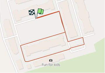
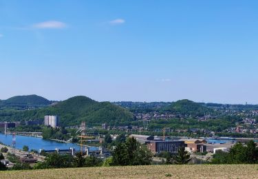
Trail Walking of 651 m to be discovered at Wallonia, Liège, Blegny. This trail is proposed by Alfredy.
Description
Tests des doubles lignes parallèles
Aussi pour prévenir avant les tournants - point projeté vers l'avant et ensuite aussi en fonction de la vitesse.
Reste pour un Champion quid des petits tourants forts proches ??
Positioning
Country:
Belgium
Region :
Wallonia
Department/Province :
Liège
Municipality :
Blegny
Location:
Unknown
Start:(Dec)
Start:(UTM)
689172 ; 5614716 (31U) N.
Comments
Trails nearby
![Trail Walking Blegny - 2023-07-28_14h00m33_1702.gpx.xml - Photo](https://media.geolcdn.com/t/375/260/ext.jpg?maxdim=2&url=https%3A%2F%2Fmedia.geolcdn.com%2Ff%2F08e717c2-a47c-47f0-9a4e-fb7b564b3f18.jpg)
![Walking Walking](https://static1.geolcdn.com/sitytour/trail-icons/101.png)
2023-07-28_14h00m33_1702.gpx.xml
Walking
Easy
(1)
Blegny,
Wallonia,
Liège,
Belgium
![](/images/other/stat-length.png)
9.9 km | 11.8 km-effort
2h 40min
![](https://static1.geolcdn.com/siteimages/upload/files/16400158638029165_repeat_loop_refresh_sync_direction_icon.png)
Yes
![Trail Walking Blegny - 20230703 - Blegny-Mine 6.8 Km - Photo](https://media.geolcdn.com/t/375/260/ext.jpg?maxdim=2&url=https%3A%2F%2Fmedia.geolcdn.com%2Ff%2F840a4c96-62cb-4388-9c6c-d720f9bd1cc9.jpeg)
![Walking Walking](https://static1.geolcdn.com/sitytour/trail-icons/101.png)
20230703 - Blegny-Mine 6.8 Km
Walking
Medium
(1)
Blegny,
Wallonia,
Liège,
Belgium
![](/images/other/stat-length.png)
6.8 km | 8.6 km-effort
2h 8min
![](https://static1.geolcdn.com/siteimages/upload/files/16400158638029165_repeat_loop_refresh_sync_direction_icon.png)
Yes
![Trail Walking Soumagne - 2021-10-28_12h59m26_1395 - Photo](https://media.geolcdn.com/t/375/260/ext.jpg?maxdim=2&url=https%3A%2F%2Fmedia.geolcdn.com%2Ff%2Fa90bb153-f7f9-4ccc-abe3-d0c8ad0a64f0.jpg)
![Walking Walking](https://static1.geolcdn.com/sitytour/trail-icons/101.png)
2021-10-28_12h59m26_1395
Walking
Easy
(3)
Soumagne,
Wallonia,
Liège,
Belgium
![](/images/other/stat-length.png)
10.4 km | 13.4 km-effort
3h 2min
![](https://static1.geolcdn.com/siteimages/upload/files/16400158638029165_repeat_loop_refresh_sync_direction_icon.png)
Yes
![Trail Walking Blegny - Mortier - Photo](https://media.geolcdn.com/t/375/260/ext.jpg?maxdim=2&url=https%3A%2F%2Fmedia.geolcdn.com%2Ff%2F8ae971b0-94ee-4292-831a-4bed9649b36e.jpg)
![Walking Walking](https://static1.geolcdn.com/sitytour/trail-icons/101.png)
![Trail Walking Fléron - F15 Fléron Fond du Pucet - Photo](https://media.geolcdn.com/t/375/260/ext.jpg?maxdim=2&url=https%3A%2F%2Fmedia.geolcdn.com%2Ff%2F52059866-a3d8-42bb-ace6-902ab69a25c9.jpg)
![Walking Walking](https://static1.geolcdn.com/sitytour/trail-icons/101.png)
F15 Fléron Fond du Pucet
Walking
Easy
(2)
Fléron,
Wallonia,
Liège,
Belgium
![](/images/other/stat-length.png)
4.8 km | 6 km-effort
57min
![](https://static1.geolcdn.com/siteimages/upload/files/16400158638029165_repeat_loop_refresh_sync_direction_icon.png)
Yes
![Trail Electric bike Blegny - Par les Houlpais - Photo](https://media.geolcdn.com/t/375/260/ext.jpg?maxdim=2&url=https%3A%2F%2Fmedia.geolcdn.com%2Ff%2F91501caf-acdf-43bf-a952-638e9aed87aa.jpg)
![Electric bike Electric bike](https://static1.geolcdn.com/sitytour/trail-icons/205.png)
Par les Houlpais
Electric bike
Difficult
(1)
Blegny,
Wallonia,
Liège,
Belgium
![](/images/other/stat-length.png)
37 km | 48 km-effort
2h 30min
![](https://static1.geolcdn.com/siteimages/upload/files/16400158638029165_repeat_loop_refresh_sync_direction_icon.png)
Yes
![Trail Walking Beyne-Heusay - Beyne-Heusay - Grivegnée par la Chapelle Sainte-Anne - Photo](https://media.geolcdn.com/t/375/260/ext.jpg?maxdim=2&url=https%3A%2F%2Fservices.sitytrail.com%2FGeolivesWS%2FDownloadMedia.ashx%3FTrailID%3D229568%26Media%3D20120115145851.jpg)
![Walking Walking](https://static1.geolcdn.com/sitytour/trail-icons/101.png)
Beyne-Heusay - Grivegnée par la Chapelle Sainte-Anne
Walking
Very easy
(1)
Beyne-Heusay,
Wallonia,
Liège,
Belgium
![](/images/other/stat-length.png)
5.1 km | 6 km-effort
45min
![](https://static1.geolcdn.com/siteimages/upload/files/16400158638029165_repeat_loop_refresh_sync_direction_icon.png)
No
![Trail Walking Soumagne - RF-Lg-03_Wégimont_Grande-boucle_QR2_2022-03-20 - Photo](https://media.geolcdn.com/t/375/260/ext.jpg?maxdim=2&url=https%3A%2F%2Fstatic1.geolcdn.com%2Fsiteimages%2Fupload%2Ffiles%2F1553511878bg_sport_marche.png)
![Walking Walking](https://static1.geolcdn.com/sitytour/trail-icons/101.png)
RF-Lg-03_Wégimont_Grande-boucle_QR2_2022-03-20
Walking
Difficult
(1)
Soumagne,
Wallonia,
Liège,
Belgium
![](/images/other/stat-length.png)
12 km | 14.8 km-effort
3h 21min
![](https://static1.geolcdn.com/siteimages/upload/files/16400158638029165_repeat_loop_refresh_sync_direction_icon.png)
Yes
![Trail Walking Blegny - Promenade du vendredi P10 - Photo](https://media.geolcdn.com/t/375/260/ext.jpg?maxdim=2&url=https%3A%2F%2Fmedia.geolcdn.com%2Ff%2Fb561cb32-28a1-4403-b429-4d2aa3579b8b.jpg)
![Walking Walking](https://static1.geolcdn.com/sitytour/trail-icons/101.png)
Promenade du vendredi P10
Walking
Very easy
(1)
Blegny,
Wallonia,
Liège,
Belgium
![](/images/other/stat-length.png)
1.7 km | 2 km-effort
34min
![](https://static1.geolcdn.com/siteimages/upload/files/16400158638029165_repeat_loop_refresh_sync_direction_icon.png)
Yes
Pas une erreur de navigation vocale ???