


Pointe Arpisson

mpignon
User
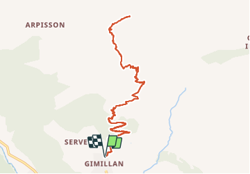

Length
12.6 km

Max alt
3069 m

Uphill gradient
1253 m
Km-Effort
29 km

Min alt
1804 m

Downhill gradient
1249 m
Boucle
Yes
Creation date :
2021-10-26 06:41:53.531
Updated on :
2021-10-27 14:55:11.387
5h13
Difficulty : Difficult

FREE GPS app for hiking
 SityTrail
IGN / Geographical institutes
SityTrail Plus
The world is yours!
About
Trail Other activity of 12.6 km to be discovered at Aosta Valley, Unknown, Cogne. This trail is proposed by mpignon.
Positioning
Country:
Italy
Region :
Aosta Valley
Department/Province :
Unknown
Municipality :
Cogne
Location:
Unknown
Start:(Dec)
Start:(UTM)
372068 ; 5052986 (32T) N.
Comments