


Breifist Markstheim

jcschubnel
User
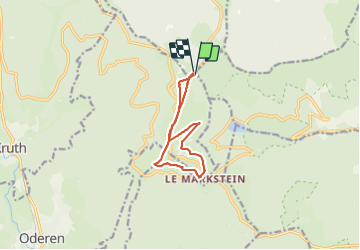

Length
9.2 km

Max alt
1280 m

Uphill gradient
265 m
Km-Effort
12.8 km

Min alt
1123 m

Downhill gradient
261 m
Boucle
Yes
Creation date :
2021-10-25 12:45:05.732
Updated on :
2021-10-27 12:54:25.776
2h12
Difficulty : Difficult

FREE GPS app for hiking
 SityTrail
IGN / Geographical institutes
SityTrail Plus
The world is yours!
About
Trail Walking of 9.2 km to be discovered at Grand Est, Haut-Rhin, Oderen. This trail is proposed by jcschubnel.
Positioning
Country:
France
Region :
Grand Est
Department/Province :
Haut-Rhin
Municipality :
Oderen
Location:
Unknown
Start:(Dec)
Start:(UTM)
352803 ; 5312337 (32T) N.
Comments