Trail  Bordes-de-Rivière - 2021-10-31_09h01m59_Cirkwi-Bordes_de_Rivière_Plaine__Les_canaux_d_irrigation_ - Photo

2021-10-31_09h01m59_Cirkwi-Bordes_de_Rivière_Plaine__Les_canaux_d_irrigation_

 jojo1412
jojo1412

User

© OpenStreetMap contributors
Length
Length
3.6 km
Max alt
Max alt
392 m
Uphill gradient
Uphill gradient
24 m
Km-Effort
Km-Effort  
3.9 km
Min alt
Min alt
381 m
Downhill gradient
Downhill gradient
24 m
Boucle
Boucle
Yes
Creation date :
2021-10-31 08:01:59.142
Updated on :
2021-10-31 08:02:00.712

(0 Reviews)


Scan this QR Code to open this trail in the SityTrail application

FREE GPS app for hiking

Logo SityTrail SityTrail

IGN / Geographical institutes

Download SityTrail from the App Store Download SityTrail from Google Play

Logo SityTrail SityTrail World

The world is yours!

Download SityTrail from the App Store Download SityTrail from Google Play Download SityTrail on Huawei AppGallery

About

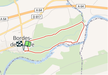
Trail of 3.6 km to be discovered at Occitania, Haute-Garonne, Bordes-de-Rivière. This trail is proposed by jojo1412.

Description

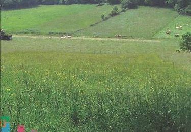
Autorisés par ordonnance royale en 1833, deux canaux d'irrigation composés de plusieurs embranchements et alimentés par la Garonne sont créés sur Bordes-de-Rivière et Villeneuve-de-Rivière pour l'arrosage des 740 hectares. Entre Garonne et canaux, se côtoient des milieux naturels : forêt alluviale, milan noir, aigrette garzette.

Elevation profile

Positioning

Country:
France
Region :
Occitania
Department/Province :
Haute-Garonne
Municipality :
Bordes-de-Rivière
Location:
Unknown
Start:(UTM)
307613 ; 4775275 (31T) N.

Trails nearby

Trail Walking Ardiège - Promenade autour d'Ardiège et de Cier de Rivière - Photo
Walking
tracegps

Walking

Easy
(1)
Ardiège, Occitania, Haute-Garonne, France
5 km | 6.4 km-effort
1h 15min
Yes
Trail Walking Cier-de-Rivière - CIER DE RIVIERE col de Couret et de l'Aouach  G4  - Photo
Walking
GUIDE
marmotte65

Walking

Difficult
Cier-de-Rivière, Occitania, Haute-Garonne, France
10.9 km | 15.1 km-effort
3h 20min
Yes
Trail Walking Labarthe-Rivière - Camon - Photo
Walking
jloger

Walking

Easy
Labarthe-Rivière, Occitania, Haute-Garonne, France
7.5 km | 8 km-effort
1h 40min
Yes
Trail Walking Cier-de-Rivière - Col de Lauach - Cier de Riviére - Photo
Walking
tracegps

Walking

Medium
Cier-de-Rivière, Occitania, Haute-Garonne, France
10.5 km | 14.8 km-effort
3h 0min
Yes
Trail Walking Ardiège - Ardiege, Cap de Rouzet nouveau chemin de parapente avec des gens  - Photo
Walking
Jeanne Pene

Walking

Medium
Ardiège, Occitania, Haute-Garonne, France
6.1 km | 10.6 km-effort
2h 50min
Yes
Trail Walking Ardiège - Depart Ardiege cap de la picote ,crete de Huntous,les arrousses plombières 2 le 06 Mars 2024 avec  eve - Photo
Walking
Jeanne Pene

Walking

Medium
Ardiège, Occitania, Haute-Garonne, France
9.1 km | 14.2 km-effort
3h 15min
Yes
Trail Road bike Villeneuve-de-Rivière - boucle dans le Comminges - Photo
Road bike
martoche

Road bike

Medium
Villeneuve-de-Rivière, Occitania, Haute-Garonne, France
68 km | 80 km-effort
3h 58min
No
Trail Road bike Villeneuve-de-Rivière - boucle commingeoise - Photo
Road bike
martoche

Road bike

Medium
Villeneuve-de-Rivière, Occitania, Haute-Garonne, France
61 km | 71 km-effort
3h 9min
Yes
Trail Walking Martres-de-Rivière - cap de  Rouzet en boucle depuis Martres de rivière  - Photo
Walking
GUIDE
lhomme.ph

Walking

Easy
Martres-de-Rivière, Occitania, Haute-Garonne, France
11 km | 16.2 km-effort
3h 18min
Yes


Close
My subscriptions