


Étang de la maison des bois

orsel
User GUIDE
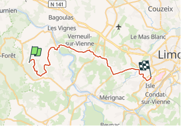

Length
23 km

Max alt
335 m

Uphill gradient
357 m
Km-Effort
28 km

Min alt
185 m

Downhill gradient
381 m
Boucle
No
Creation date :
2021-11-01 11:17:57.004
Updated on :
2021-11-01 13:40:45.375
2h21
Difficulty : Very easy

FREE GPS app for hiking
 SityTrail
IGN / Geographical institutes
SityTrail Plus
The world is yours!
About
Trail Walking of 23 km to be discovered at New Aquitaine, Haute-Vienne, Saint-Priest-sous-Aixe. This trail is proposed by orsel.
Description
marche et voiture jusque chez Phano
Positioning
Country:
France
Region :
New Aquitaine
Department/Province :
Haute-Vienne
Municipality :
Saint-Priest-sous-Aixe
Location:
Unknown
Start:(Dec)
Start:(UTM)
349239 ; 5076711 (31T) N.
Comments