


SAPENAY: TOUR DE LA MONTAGNE DE CESSENS

djeepee74
User
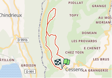

Length
6.9 km

Max alt
973 m

Uphill gradient
231 m
Km-Effort
10 km

Min alt
790 m

Downhill gradient
230 m
Boucle
Yes
Creation date :
2021-11-09 12:55:57.673
Updated on :
2021-11-11 18:13:55.475
2h10
Difficulty : Easy

FREE GPS app for hiking
 SityTrail
IGN / Geographical institutes
SityTrail Plus
The world is yours!
About
Trail Walking of 6.9 km to be discovered at Auvergne-Rhône-Alpes, Savoy, Entrelacs. This trail is proposed by djeepee74.
Positioning
Country:
France
Region :
Auvergne-Rhône-Alpes
Department/Province :
Savoy
Municipality :
Entrelacs
Location:
Unknown
Start:(Dec)
Start:(UTM)
723579 ; 5075702 (31T) N.
Comments