


Clédou 10-11-2021

jmrobin
User
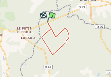

Length
4.7 km

Max alt
220 m

Uphill gradient
80 m
Km-Effort
5.7 km

Min alt
166 m

Downhill gradient
82 m
Boucle
Yes
Creation date :
2021-11-10 13:45:26.373
Updated on :
2021-11-10 15:08:26.415
1h22
Difficulty : Easy

FREE GPS app for hiking
 SityTrail
IGN / Geographical institutes
SityTrail Plus
The world is yours!
About
Trail Walking of 4.7 km to be discovered at New Aquitaine, Charente, Combiers. This trail is proposed by jmrobin.
Positioning
Country:
France
Region :
New Aquitaine
Department/Province :
Charente
Municipality :
Combiers
Location:
Unknown
Start:(Dec)
Start:(UTM)
296440 ; 5045597 (31T) N.
Comments