


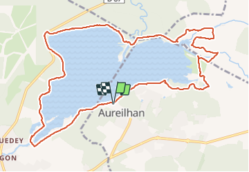
Aureilhan

yoye
User

Length
14.1 km

Max alt
22 m

Uphill gradient
99 m
Km-Effort
15.5 km

Min alt
4 m

Downhill gradient
100 m
Boucle
Yes
Creation date :
2021-11-11 10:38:12.0
Updated on :
2021-11-11 15:06:02.276
3h19
Difficulty : Easy

FREE GPS app for hiking
 SityTrail
IGN / Geographical institutes
SityTrail Plus
The world is yours!
About
Trail Walking of 14.1 km to be discovered at New Aquitaine, Landes, Aureilhan. This trail is proposed by yoye.
Description
Facile
Positioning
Country:
France
Region :
New Aquitaine
Department/Province :
Landes
Municipality :
Aureilhan
Location:
Unknown
Start:(Dec)
Start:(UTM)
643260 ; 4898012 (30T) N.
Comments